Upload one stitched drone photo of your site (a GeoTIFF orthomosaic) and Drone outlines every tree crown it can see. Look-alike crowns are grouped together, you name each group once, and every tree in that group gets the species you typed.
Every run is saved on its own, so you can change the settings and try again whenever you like. Download a species map for Google Earth or any GIS tool, CSV tables with every crown and its species, and a STAC record.
How to use it
1
Create a project: Sign in with Google, then start a new project for your site.
2
Upload orthomosaics: Add a GeoTIFF (.tif or .tiff) with its coordinates built in, from your computer or a Google Drive link shared as "Anyone with the link". A ground resolution finer than 8 cm per pixel works best, and a project takes up to 10 orthomosaics and 5 GB. If the file has no coordinates, the app asks for the EPSG code.
3
Detect and group: Pick a detector model and settings, then run the analysis. Drone outlines the crowns and groups look-alike ones. The elbow, silhouette and Davies-Bouldin charts suggest how many groups to use, and the t-SNE crown map shows how clean those groups are.
4
Check and tune: Compare the red outlines on the detection overlay with the trees you can see. If results look poor, open the Guide tab, change the suggested setting and run again.
5
Name and export: Type a species for each group, then export the species map (KMZ), CSV tables and STAC record. Every run gets its own read-only folder in FileBrowser.
Watch it in action
Pipeline walkthrough
▷Tutorial coming soon
The walkthrough will appear here when it is available.
From a drone orthomosaic to a tree species map.
A walkthrough of Drone, from signing in to exporting and finding your files.
The video could not be loaded. Check your connection and try again.
Open-source tree-crown detector: Mask R-CNN instance segmentation, built on Meta's detectron2.
Each tile returns a crown outline and a confidence score.
Published weights are used as they are. Nothing is trained here.
Weights are mounted read-only at /models and can be picked per project:
Weights
Best for
urban_cambridge
Urban trees, Cambridge UK. Default.
paracou
Tropical canopy, Paracou UAV.
randresize
Random-resize full model.
flexi
Generalist: urban and closed canopy.
tropical_closed
Dense tropical forest only.
The detector only finds crowns. Naming the species is the clustering and labelling work that follows.
Crown embedding: DINOv2
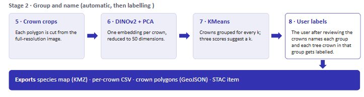
Each crown polygon is cut from the full-resolution orthomosaic.
A DINOv2 vision transformer returns one embedding per crown.
Embeddings are L2-normalised, standardised, then reduced with PCA to 50 components (configurable).
The backbone can be picked per run:
Backbone
Trade-off
ViT-S/14
Fastest, smallest embeddings.
ViT-B/14
Balanced. Default.
ViT-L/14
Highest quality, slowest.
Clustering and choosing k
Look-alike crowns are grouped with KMeans, once for every k in the list. The default list is 2, 4, 6, 8, 10.
The elbow, silhouette (higher is better) and Davies-Bouldin (lower is better) scores are computed for every k.
The best k is suggested (the red dashed line on the plot), but you can choose any k after reviewing.
For review, the app also shows the crowns nearest each group's centre and a t-SNE map of all crowns. Tight, separate patches of colour mean clean groups; mixed colours mean you should try another k.
Naming species
Clustering only groups crowns. You supply the species names after reviewing the cropped crowns.
The review page shows sample crowns for every group at the chosen k.
You type one species per group, and every crown in the group inherits it.
Two groups can be given the same species.
Labels are stored per run, so an older run can still be finished later.
Example result
782tree crowns detected
206labelled acacia (26%)
576labelled non-acacia (74%)
One orthomosaic at 2 cm/px, k = 2, with Detectree2 (urban_cambridge) and DINOv2 ViT-B/14. Species come from the user-named clusters.
Outputs
Species map (KMZ): opens in Google Earth or any GIS tool.
CSV tables: every crown with its species, ready for Excel.
Crown polygons (GeoJSON).
STAC record: so the dataset can be catalogued and found later.
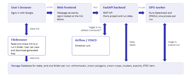
FileBrowser folder: a shareable, read-only link to every file of the run.
Every run is kept: compare settings and finish any run later.
Limitations and what they imply
Limitation
What it means
Detection is not identification
Detectree2 only outlines crowns. A missed or merged crown is a detection problem, not a labelling one.
Species come from you
Groups are made by visual similarity. A group is only as accurate as the name you give it after reviewing the sample crowns.
Groups are not always species
A species can split across several groups, so two groups can share one name. Check the t-SNE map before trusting a k.
Weights are used as published
Nothing is trained here, so pick the weights closest to your forest type.